2013-06-23 Estes Cone from Storm Pass Trail
You can see the GPS tracks for this entire hike.
The video shows: East Portal Trailhead (0:00-0:05), Wind River near trailhead (0:06-0:14), meadow below Storm Pass Trail (0:15-0:35), views from Estes Cone summit area (0:36-1:19), views from Storm Pass Trail (1:20-1:49).
In Estes Park, we parked at the end of Tunnel Road at the shuttle bus parking area, and hiked up the gravel road to the Adams Tunnel East Portal. We then started up the Wind River Trail which begins on the north side of the tunnel outlet.
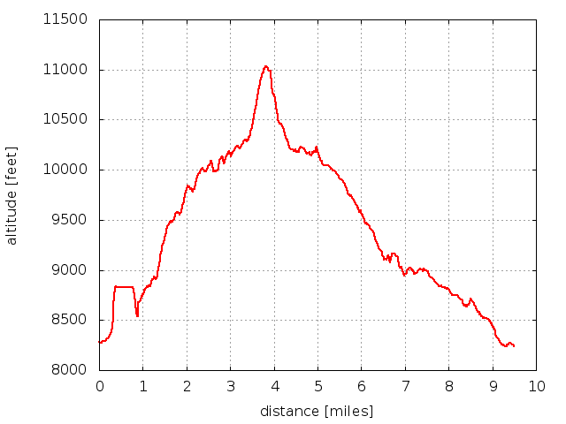
At 0.88 miles (alt 8537 ft, 40.319200,-105.585000), we turned left at the sign for "Wind River Bluff" campsite, crossing the campsite's log bridge over the creek, and then departed the trail entirely, following the slope of steepest ascent. We soon reached the top of a ridge and continued ascending along the ridge top southward. Some of the rock knobs, we circumvented, as we ascended through fairly easy going but ocassionally very steep lightly forested terrain. At an elevation of 9,845 ft we came upon the Storm Pass Trail, which we turned left onto, heading to Storm Pass. The off-trail part of this hike luckily turned out to be a fairly efficient way to get to Estes Cone from where we started. If the terrain happened to be rougher, it would have been a different story.
We reached the Estes Cone summit at about 11:15, having hiked 3.83 miles so far. It was a fairly clear day, with a fantastic view of Longs Peak and Mt Meeker. There were 4 people on the summit, one of which was a man with a deep voice who offered a kid, who had hiked up with his Mom, an egg salad and bacon sandwich. He said that he also had three-berry pie, which he announced he was not nice enough to share.
With the summit, being crowded, we descended a bit before stopping for lunch. For the return, we stayed on the Storm Pass Trail all the way to the Wind River Trail, then turned right at the intersection where the sign says 2.0 miles to East Portal. This was a much longer distance than the way we came, but easier going since it was all trail.
We returned at 15:17, with the GPS tracks showing a total distance of 9.5 miles. Elevation change from lowest (parking) to highest (summit) was 11041-8264 = 2,777 feet.
On a side note, we crossed the Iron Dike three times on this hike. These are points we weren't aware of before.

2013-06-15 Elevation profile: Estes Cone from Adams Tunnel East Portal and back
| Place Name | Elev [ft] | Accuracy [ft] | Position (lat,lon) |
|---|---|---|---|
| Parking at end of Tunnel Rd | 8,264 | 20 | 40.32834,-105.57564 |
| Iron Dike, position 1 | 9,488 | 36 | 40.30866,-105.58493 |
| Reached Storm Pass Trail | 9,845 | 20 | 40.30415,-105.58644 |
| Estes Cone summit | 11,041 | 16 | 40.29528,-105.56722 |
| Iron Dike, position 2 | 9,619 | 26 | 40.30554,-105.59151 |
| Iron Dike, position 3 | 9,388 | 30 | 40.30846,-105.59369 |
© 2012-2013 Stefan Hollos and Richard Hollos
Tweet

blog comments powered by Disqus