Butzel Hill (8,264 ft) and Point 9089, 03/14/2009
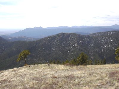
Butzel Hill from Nugget Hill, 05/04/08
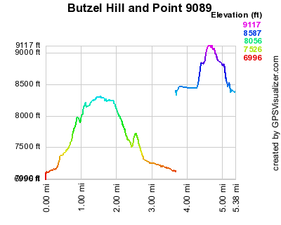
Elevation versus distance, 03/14/09
Butzel Hill is a Boulder County peak on the south side of Lefthand Canyon near Rowena. It is east of Bighorn Mtn, west of Lee Hill, and opposite the canyon from Nugget Hill. It is an unranked Roach.
Point 9089 is farther up the canyon, on its north side, southeast of Ward.
You can see the GPS tracks for this entire hike.
Parking at Rowena, beside Lefthand Canyon Drive, we started hiking, at 10:26, up the 4WD road across from "Stephen Strand, The Handyman".
Hiking for about 0.2 miles up the 4WD road, we departed the road, turning right and going up the steep north slope of Butzel Hill. We headed southeast up the slope, through pretty thick forest and brush to the west ridge of Butzel Hill. This mountain is covered in 100 year old mining trails and gopher holes, and we occasionally did use some overgrown mining trails on the way up.
At about 1.0 mile, we reached the west ridge of Butzel Hill, very near to a house that is off of Sunshine Canyon Drive. We headed east along the ridge for about 0.3 mile to the summit of Butzel Hill.
We reached the Butzel Hill summit at 11:28, with the odometer at 1.28 miles. It was sunny and warm, with almost no wind on the summit. Much different then the last time we were there in Apr 2006, with a hurricane force wind. On the north side of the summit there is a great view of Nugget Hill and its long ridge. The Indian Peaks, and Sugarloaf Mtn can also be seen from here.
On our descent, we headed down the east ridge for awhile, then northwest, ascending a bit over the northeast ridge, and finally back along the 4WD road we started on.
Returning at 13:00, the odometer showed 3.47 miles. The elevation difference from lowest (parking) to highest (Butzel summit) was 1,179 feet, and the trip time was 2 1/2 hours.
For Point 9089, we parked off Lefthand Canyon Drive at an elevation of 8408 feet, just southwest of Ward. We started hiking at 13:28, ascending the steep southeast slope, through lightly wooded forest. Reaching the summit of Point 9089 at 13:52, the odometer showed about 0.7 miles from the start.
There was no summit marker on Point 9089, so we made a small cairn. The views aren't great, because of the trees, but on the west side of the summit, where some trees have been cleared, there is a good view of Niwot Mountain. We had lunch there, before returning approximately the way we came, getting back at 15:12.
- Richard Hollos and Stefan Hollos
| Place name | Elev [ft] | Accuracy [ft] | Lat/Lon |
|---|---|---|---|
| Parking at Rowena | 7100 | 17 | 40.07817,-105.38486 |
| Butzel Hill summit | 8279 | 10 | 40.07399,-105.37492 |
| Parking for Point 9089 | 8408 | 13 | 40.05796,-105.49098 |
| Point 9089 summit | 9112 | 14 | 40.06181,-105.49444 |