Chasm View, 10/05/2007
Chasm View is an overlook on the north side of Longs Peak, south of the Boulder Field. It provides a terrific closeup view of the East Face of Longs Peak, Mills Glacier, and Chasm Lake. It is near the start of the old cable route to the summit of Longs Peak. You've got to watch your step here, there is a cliff on the east side of Chasm View, facing the East Face of Longs Peak.
We started hiking at 7:46 from the parking area of the Longs Peak Ranger Station. Surprisingly there were plenty of parking spaces. The aspens around the parking area were beautiful with their golden leaves. This place really is nice when the tourist season is over.The weather was great, and the temperature was just right, as we cruised uphill on the trail, reaching the Chasm Lake junction at 9:10. The sign at the Chasm Lake junction shows 3.5 miles back to the Ranger Station, while our gps odometer showed 2.56 miles. Apparently our gps wasn't tracking the whole way and had connected the dots between the missing parts.
We reached Granite Pass at 9:40, and headed up to the Boulder Field, getting there at 10:12. In the Boulder Field we left the main route and turned left at the "Leave Trail" point listed below, and headed in the direction of Chasm View.
Reaching the ridge that Chasm View is on, we followed it up toward Chasm View. We got a really nice view of Chasm Lake as we reached an elevation of 13289 feet. There was already some fresh snow and ice on the rock, starting about here. We got to a knob on the ridge where the snow and ice prevented us from safely continuing up, so we had to descend, go around the knob, then ascend again up to Chasm View.
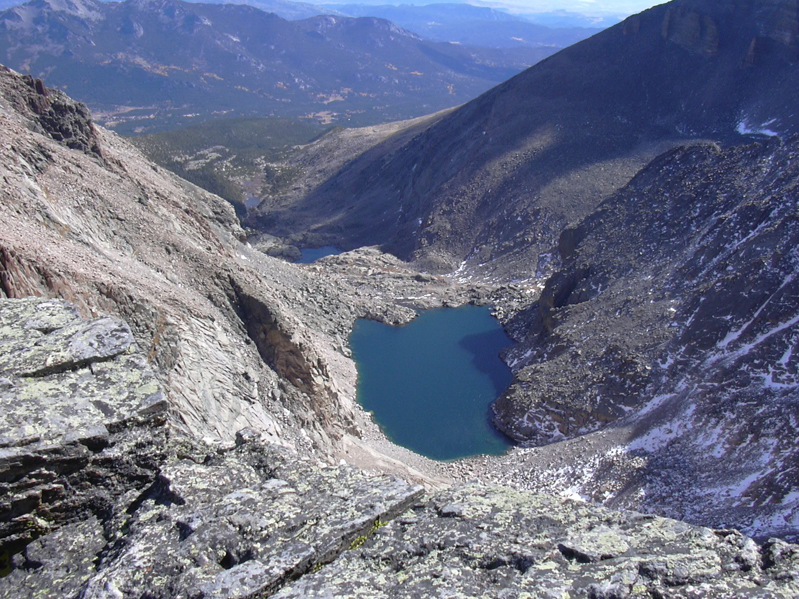
We reached Chasm View at about noon. The gps showed an elevation of 13550, and the odometer showed 5.75 miles. Approximately the last hundred feet was tricky to ascend with just hiking boots because there was significant new snow and ice.
On the return we didn't go back the way we had come, but descended more directly down toward the Boulder Field along a well worn path that apparently was established when the cable-route was the most popular ascent route up Longs Peak. We could have saved a lot of time ascending by this route also.
Going back, we passed the Chasm Lake junction at 13:44, and returned to the parking area at 15:45.
The total time for this hike was 8 hours, with an elevation gain of 4143 feet.
| Place name | Elev [ft] | Accuracy [ft] | Lat/Lon |
|---|---|---|---|
| Longs Peak parking area | 9407 | 22 | 40.27214/105.55666 |
| Chasm Lake junction | 11537 | 16 | 40.26566/105.59261 |
| Granite Pass | 12105 | 16 | 40.27411/105.60542 |
| Chasm View | 13550 | 16 | 40.25766/105.61596 |
| Number | Description | Lat/Lon |
|---|---|---|
| 1 | Chasm View | 40.2575/105.6153 |
| 2 | Leave Trail | 40.2637/105.6145 |
Topo Map of the Chasm View area