Coffintop Mountain (8,049 ft) from Coffintop Gulch, 12/07/2008
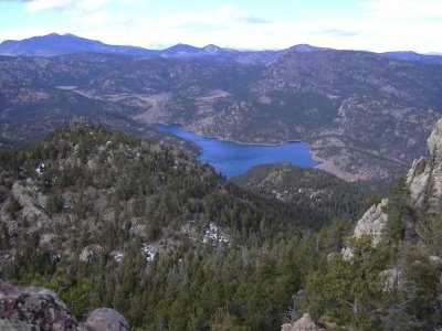
Ralph Price Reservoir from Coffintop Mtn summit, 12/07/08
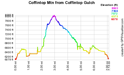
Elevation versus distance, 12/07/08
Coffintop Mountain is a prominent foothills peak, visible from the Heil Ranch Overlook, the Hall Ranch parking area, and Longmont. Its name obviously comes from its long flat summit area running north to south. Despite its close proximity to Lyons and Longmont, it's not a popular peak to climb, possibly due to its name. It's north of CO Hwy 7, in the foothills west of Lyons. It's just southeast of Ralph Price Reservoir (aka Button Rock Res.), and west of Deadman Gulch.
We've climbed Coffintop Mtn numerous times, but never before from Coffintop Gulch, mainly because access to Coffintop Gulch from Hwy 7, is blocked by a fence, behind which is apparently private property.
You can see the GPS tracks for this entire hike.
Parking just off CO Hwy 7, at a pulloff about 1/2 mile west of Coffintop Gulch, we started hiking at 10:28, ascending a faint trail on the north side of the highway. Further up, it appears that this trail has recently had some improvements made to it. The trail eventually fades out, and we soon were on top of a ridge on the south side of Coffintop Gulch.
From the top of the ridge, we headed down the north side of the ridge in a northwest direction following a deer trail to Coffintop Gulch. Coffintop Gulch is a wilderness that appears to have been left alone after miners pulled out about a hundred years ago.
There is an old mining road, which appears to have had no use for many decades, paralleling the length of the gulch. Ascending west along the gulch, we followed this old road until our GPS showed we were directly south of the summit, at which point we turned right, following a small gulch north to the summit. As we neared the summit, we went around to the west side, then up to the summit area, as the southeast side has some extremely steep rocky areas.
We reached the Coffintop summit at 12:31, with the odometer at 2.17 miles. Near the summit, we found a CMC register, which we signed. The last entry before us was Jennifer Roach and two other women, six days before on Dec. 1.
The summit was very windy, so after signing the register and taking a few pictures we started heading down at 12:59. From the summit we headed west to the Coffintop-West Coffintop saddle, skirted around the south side of the West Coffintop summit, and continued to the West Coffintop-Peak 8030 saddle. After enjoying lunch there, in the sun with some birds, we headed southeast on an old mining road, which is the same road that we were initially following in Coffintop Gulch.
Taking the mining road back down to Coffintop Gulch, we closed the loop on our incoming tracks, then ascended back up the ridge that we entered the gulch by. From the ridge we made it down to our parking place on Hwy 7.
Ending the hike at 15:27, our odometer showed 6.32 miles, with a roundtrip time of 5 hours. The total elevation gain was about 2600 feet.
- Richard Hollos and Stefan Hollos
| Place name | Elev [ft] | Accuracy [ft] | Lat/Lon |
|---|---|---|---|
| Parking off CO Hwy 7 | 6086 | 8 | 40.18277,-105.34216 |
| Coffintop Mtn summit | 8036 | 17 | 40.19764,-105.35629 |