Nugget Hill Ridge via Miner's Ass Trail, 03/06/2010

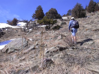
Stefan on Miner's Ass Trail, 03-06-10

Nugget Hill from east ridge, 03-06-10
You can see our GPS tracks for this hike.
We parked off Lefthand Canyon Drive about 1/2 mile past its intersection with James Canyon Drive, and about 100 feet before a Lefthand firestation, where there is a wide pulloff on the south side of the road, at an elevation of 6500 feet.
On the north side of the road, an old miner's ass trail (check out Colorado's most famous ass, Prunes) starts on the east side of the firestation. This trail is faded from a hundred years of neglect, but you can still see the rocks forming its edge along much of the way.
Starting our hike at 10:10, we followed the miner's ass trail, and proceeded in a northwest direction along the south slope of Nugget Hill. After about 1 mile, the trail faded out in a meadow at about 7900 feet.
From the meadow we headed west about 1/10th mile, then northwest to the top of a knob on the ridge, getting there at 11:59, with the odometer at 1.4 miles.
The GPS showed an elevation of 8275 ft on this knob. It's got great views, and was a nice place for lunch.
From the knob, we headed west along the ridge until the snow got deep enough to be a pain. This was our high point at 8329 feet. From there, we headed back in the direction we came.
We returned at 15:29, with the odometer at 3.2 miles. The elevation gain for this hike was about 1800 feet.
- Richard Hollos and Stefan Hollos
| Place name | Elev [ft] | Accuracy [ft] | Lat/Lon |
|---|---|---|---|
| Parking | 6501 | 30 | 40.09450,-105.34896 |
| Top of knob | 8275 | 16 | 40.09826,-105.36827 |
| High point | 8329 | 20 | 40.09851,-105.37132 |