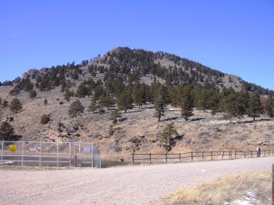
Mount Olympus (8,808 ft) and Emerald Mountain (9,237 ft), 02/28/2009

Mount Olympus from US Hwy 36, 02/28/09

Emerald Mtn from Adams Tunnel outlet, 02/28/09

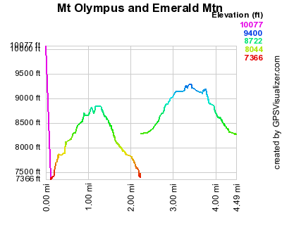
Elevation versus distance, 02/28/09
Mount Olympus and Emerald Mountain are Larimer County peaks that are both adjacent to Estes Park. Mount Olympus is a prominent peak visible from Estes Park to the east. Its north side is national forest, while its south side is private land. Emerald Mountain is southwest of Estes Park, near the YMCA. Most of it is part of Rocky Mountain National Park, but its east and north sides have some private land.
You can see the GPS tracks for this entire hike.
In Estes Park, from the intersection of Mall Road and US-34, we drove 0.8 miles east on US-34 and parked next to the Roosevelt National Forest sign.
We hadn't done Mount Olympus before, and Luke Plumely had said he would show us the way up. Besides Luke, we hiked up with Corrinne Plumely, Dave Lensink, Pete Krzanwski, and Mike Offerman.
At 9:12, near the national forest sign, we started up a steep faint trail, marked with cairns. This cairned route starts by paralleling a gully, going southeast, then after the slope becomes less steep, heads south to the summit.
We reached the summit at 10:21, with the odometer at 1.1 miles. The summit is on the edge of a precipice, and the views are spectacular and panoramic. Some of the things visible from the summit are Estes Park, Longs Peak, and Lumpy Ridge.
Returning the way we came, we got back to our parking place at 11:24, with the odometer at 2.32 miles.
For Emerald Mtn, we parked at the end of Tunnel Road, past the YMCA, near the Adams Tunnel outlet. We started hiking at 12:04, crossing over the Adams outlet dam, then headed northwest up the slope of Emerald Mtn, then west along a trail. At the intersections of the East Portal Trail, YMCA Trail, and Glacier Basin Campground Trail, we left the trail, and headed up the slope to the Emerald summit.
We reached the summit of Emerald Mtn at 12:36, with the odometer at 1.02 miles. On the west side of the summit, there are great views of Glacier Basin Campground, Sprague Lake, Thatchtop Mtn, the mountains from Flattop to Taylor Peak, Stones Peak, Sundance Mtn, the Mummy Range, and Rams Horn.
After having lunch near the summit, we returned to our parking place at 13:40, with the odometer at 2.23 miles.
The hike up Mt Olympus had an elevation gain of 1,449 ft, while Emerald Mtn was 967 feet, for a total gain of 2,416 feet. Each hike was about a mile from the parking place to the summit.
- Richard Hollos and Stefan Hollos
| Place name | Elev [ft] | Accuracy [ft] | Lat/Lon |
|---|---|---|---|
| Parking for Mt Olympus | 7382 | 7 | 40.38178,-105.47058 |
| Mt Olympus summit | 8831 | 7 | 40.37487,-105.46196 |
| Parking for Emerald Mtn summit | 8285 | 6 | 40.32814,-105.57573 |
| Emerald Mtn summit | 9252 | 8 | 40.33062,-105.58704 |