Mount Orton (11,724 ft) from Castle Lake, 10/18/2008

Castle Lake with Mt Alice, 10/18/08

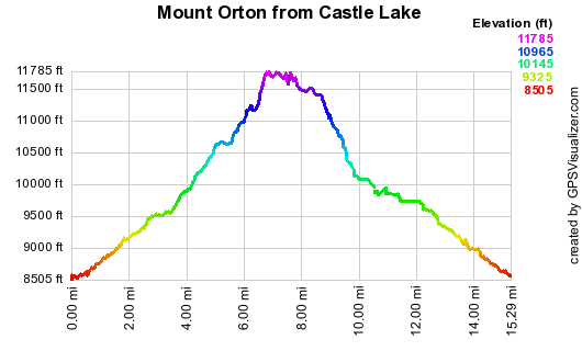
Elevation versus distance, 10/18/08
Mount Orton, in the Wild Basin area of Rocky Mountain National Park, separates the Hunters Creek drainage from Lion Lakes. It provides an outstanding view of Longs Peak, Mt Meeker, Pagoda Peak, and Chiefs Head. Its ridge also serves as a route to the summit of Chiefs Head. Mt Orton is on Roach's Boulder County Peaks list, and is unranked.
You can see the GPS tracks for this entire hike. There are some gaps, due to the GPS not tracking.
We started hiking at 9:01 from the Wild Basin parking area near the Ranger Station. Reaching the Ouzel Falls Trail and Thunder Lake Bypass Trail junction at 9:28, the odometer showed 1.47 miles. Turning right onto the Bypass Trail, we reached the intersection with the Thunder Lake Trail at 10:02. Turning right onto the Thunder Lake Trail, we continued to its intersection with the Lion Lakes Trail, getting there at 10:34 with the odometer at 3.99 miles. Hiking up the Lion Lakes Trail, we turned right, leaving the trail, just a couple hundred yards before Lion Lakes #1, heading toward Castle Lake.
We reached Castle Lake at 11:40, with the odometer showing 6.24 miles. This is such a beautiful lake, we were tempted to just relax on its shore and enjoy the view of Mt Alice the rest of the day. But we pressed on, taking the elk trail on the southeast side of the lake, up the very steep slope to the top of the Mt Orton Ridge.
We reached the top of the Mt Orton Ridge at 12:15. The view there was spectacular with the vast encompassing view of Meeker, Longs, and Pagoda Peak. From the ridge, we headed southeast to the summit of Mt Orton.
We reached the Orton summit at 12:48, with the odometer showing 7.38 miles. We did not find a register on this summit. Leaving the summit we continued southeast along the Orton Ridge, then turned east toward Sandbeach Lake, and southeast again, reaching a large meadow area with a small lake, which we'll call Dinky Lake.
A word of caution: the south and southeast sides of Mount Orton are peppered with cliffs, and one's descent route should be planned ahead of time, using a topomap map, as we did, to avoid them.
We reached Dinky Lake at 14:30, with the odometer showing 9.79 miles. From Dinky Lake, we headed southwest toward Twin Lakes, where we had lunch, before hiking another 0.3 miles to the Thunder Lake Trail, which we arrived by.
The section of our route from treeline to Dinky Lake, to Twin Lakes, back to the trail, was trackless forest, but thankfully not incredibly dense forest.
From the Thunder Lake Trail, we headed back the way we came. Further down the trail, at 15:46, we met the first people we had seen all day. We returned to our parking place at 16:45, with the odometer at 14.4 miles. The total trip time was 7 hrs, 44 minutes.
The elevation difference from lowest (parking) to highest (reaching top of Orton Ridge) was 3,219 feet, with a total distance of 14.4 miles. The elevation gain versus distance is shown in the graph.
- Richard Hollos and Stefan Hollos
| Place name | Elev [ft] | Accuracy [ft] | Lat/Lon |
|---|---|---|---|
| Parking at Wild Basin Ranger Station | 8542 | 6 | 40.20792,-105.56680 |
| Ouzel Falls Tr/Thunder Lake Bypass Tr Inter. | 8918 | 23 | 40.20021,-105.58821 |
| Thunder Lake Bypass Tr/Thunder Lake Tr Inter. | 9500 | 17 | 40.20508,-105.60667 |
| Lion Lake/Thunder Lake Tr Inter. | 10034 | 23 | 40.21289,-105.62495 |
| Castle Lake east shore | 11174 | 9 | 40.22966,-105.63358 |
| First reaching top of Mt Orton Ridge | 11761 | 10 | 40.23102,-105.62888 |
| Mount Orton summit | 11755 | 6 | 40.22721,-105.61971 |
| Dinky Lake | 10143 | 37 | 40.21154,-105.60216 |