Yellowstone Trip, 09/13/2008

Otis Peak from top of Andrews Glacier, 08/30/08
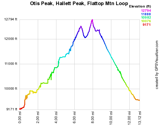
Altitude versus distance for Otis, Hallett, Flattop Loop, 08/30/08
You can see the GPS tracks for this entire hike. There are some gaps, due to the GPS not tracking.
This was a 13.4 mile loop starting at the Glacier Gorge Trailhead, to Andrews Glacier, to Otis Peak, to Hallett Peak, to Flattop Mountain, and ending at Bear Lake.
Taking the shuttle bus up to the Glacier Gorge Trailhead, we started hiking up the Glacier Gorge Trail at 9:16. At 0.3 miles, we turned right onto a "shortcut", and eventually met with the Lake Haiyaha Cuttoff Trail. Turning left on this trail, we continued to the intersection with The Loch Trail, turning right onto that at 10:33. Hiking up past The Loch, to the intersection with the Sky Pond and Andrews Glacier Trails, we turned right toward Andrews Glacier at 11:16.
We reached Andrews Tarn at 12:03, with the odometer showing 5.48 miles. The turqoise color of this little pond, along with the white glacier and the blue sky, is something to behold.
Ascending straight up Andrews Glacier with only hiking boots, we reached Andrews Pass at 12:32, with the odometer at 6.34 miles. It was almost all soft snow, with just a few icy spots. Only the north side of the glacier had a large area of snow melted away to reveal the ice beneath.
From the pass, we could see Andrews Tarn and The Loch down below. And to the left (northeast) was a great view of Otis Peak.
Heading north, along the Divide, we soon turned northeast and ascended to the summit of Otis Peak, getting there at 13:06. The Otis summit has a great view of Taylor Peak, the first peak south of Andrews Pass along the Divide.
Leaving the summit of Otis Peak, we headed northwest then north toward Hallett Peak. We reached the Otis-Hallett saddle at 13:38, and then continued on to the Hallett summit, getting there at 14:10. Hallett has great views of Otis Peak (south), Snowdrift Peak (west), and Stones Peak (northwest).
From Hallett, we headed over to Flattop, reaching the intersection of the Flattop Mtn Trail and the Tonohutu Creek Trail at 14:39, with the odometer at 8.97 miles. From there we returned along the Flattop Mtn Trail, getting to the Bear Lake parking area at 16:42, with the odometer at 13.4 miles. We then took the shuttle bus down to Park and Ride.
The total trip time for this hike was 7 hrs, 26 minutes, with an elevation difference from lowest (Glacier Gorge TH) to highest (Hallett Pk) of 3552 feet.
- Richard Hollos and Stefan Hollos
| Place name | Elev [ft] | Accuracy [ft] | Lat/Lon |
|---|---|---|---|
| Glacier Gorge Trailhead | 9198 | 13 | 40.31037,-105.64032 |
| Andrews Tarn | 11373 | 15 | 40.28859,-105.67843 |
| Andrews Pass | 11983 | 16 | 40.28727,-105.68620 |
| Otis Peak summit | 12507 | 6 | 40.29235,-105.68050 |
| Otis-Hallett Pass | 12066 | 6 | 40.29375,-105.68710 |
| Hallett Peak summit | 12750 | 8 | 40.30300,-105.68596 |
| Flattop Mtn Trail and Tonohutu Creek Trail | 12356 | 15 | 40.30891,-105.69025 |