Peak 8140 from Barking Dog Trail and Balarat, 12/13/2008
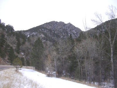
Peak 8140 from Hwy 7 at Barking Dog, 12/13/08
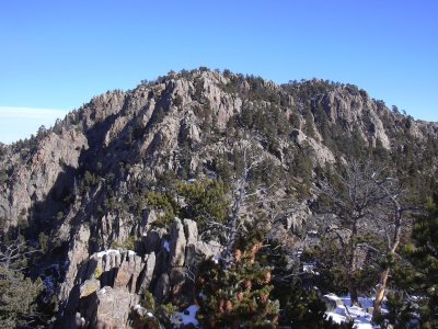
Peak 8140 from west, 12/13/08
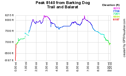
Elevation versus distance, 12/13/08
Peak 8140 is visible from CO Hwy 7, west of Lyons, near mile marker 24 and the Barking Dog Trailhead. It's on Gerry Roach's Boulder County Peaks list, with a rank of 64. Its elevation is not shown on topo maps.
You can see the GPS tracks for this entire hike.
Parking at a pulloff next to Hwy 7, near mile marker 24, we started hiking at 9:57. We crossed the bridge over the St Vrain Creek then proceeded up toward the old mining town of Balarat, along the Barking Dog Trail.
Before Balarat, we turned left near a gulley, leaving the trail and heading east up to Point 7979, reaching its top at 10:53, with the odometer at 1.70 miles.
From Point 7979, we headed east along ridgetops toward the summit of Peak 8140. From the saddle just east of the summit, there are some rock knobs, which we avoided by going around their south side, and then northeast to the summit. We reached the 8140 summit at 11:43, with the odometer at 2.86 miles.
The summit register, which we had found there almost 3 years ago, placed by Mike Garratt, was gone. On the summit, there are some great views. To the southeast is Peak 8315 and Fairview Peak's sibling, Peak 8588. To the northeast is Coffintop Mountain. And to the west is the high country, which today was cloaked in falling snow, and was heading our way.
For the return, we left the summit off its east side, then formed a clockwise loop before returning to our incoming tracks. We left our incoming tracks again, and headed south to the top of Peak 8051, getting there at 13:43, with the odometer at 6.42 miles. The view from that summit is also very nice, with the meadow area east of Central Gulch.
After having lunch on the 8051 summit, we headed west, stopping at an overlook bench, apparently put there by Cal-Wood . We then descended northwest to Long Gulch, and followed the gulch down to Balarat and the Barking Dog Trail.
We returned to our parking place at 15:12, with the odometer at 9.06 miles. The total trip time was 5 hrs, 15 minutes. The total elevation gain with some ups and downs, was about 2,000 feet.
- Richard Hollos and Stefan Hollos
| Place name | Elev [ft] | Accuracy [ft] | Lat/Lon |
|---|---|---|---|
| Parking off CO Hwy 7 (near mile marker 24) | 6945 | 16 | 40.16780,-105.38801 |
| Point 7979 | 8033 | 11 | 40.16095,-105.38672 |
| Peak 8140 | 8209 | 8 | 40.16371,-105.37346 |
| Peak 8051 | 8067 | 15 | 40.15545,-105.38811 |
| Cal-Wood Overlook Bench | 7979 | 7 | 40.15668,-105.39194 |