Point 7201 and Point 7800 from Lefthand Canyon OHV Area, 12/21/2008

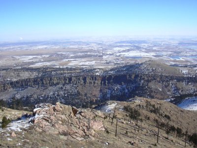
Looking east from Point 7201 summit, 12/21/08

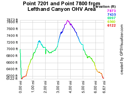
Elevation versus distance, 12/21/08
Point 7201 and Point 7800 are southeast of Fairview Peak, and east of Golden Age Hill. Point 7201 is #72 on Roach's Boulder County Peaks List. Point 7800 is not on that list, and in fact doesn't have an elevation on topomaps. We call it 7800 because that's the highest topo line shown on the map. These points are most directly accessible from the Lefthand OHV Area, just off Lefthand Canyon Drive. This is where Jeepers go on weekends. The vicinity of the entrance to this area is also a popular place where bubbas do target shooting. Stray bullets have been a problem in the past. This somewhat detracts from the enjoyment of hiking in the area.
You can see the GPS tracks for this entire hike.
From US Hwy 36, we turned west onto Lefthand Canyon Drive and drove 3.8 miles to the Lefthand OHV area where there's an entrance sign to Roosevelt National Forest. Parking there, we started hiking at 11:32 on this bitterly cold morning, going north on Forest Road 286. After 2/10 mile, the road takes a sharp left, as we continued straight (north) onto the beginning of Trail 842.
Hiking north on trail 842, we ascended to the top of a ridge. Trail 842 ends there, and two other trails begin. Trail 840 goes to the right (east) toward Point 7201, and Trail 841 goes to the left (west) toward Point 7800. At this intersection, the odometer showed 0.96 miles.
Heading east on Trail 840, we followed it until we neared the summit, then made a beeline for it, getting there at 12:28, with the odometer at 1.43 miles.
After taking a few pictures and enjoying the view, we headed back along the ridge to the 3-way trail intersection we came from. Returning to that point, the odometer showed 2.18 miles.
Going west on Trail 841, we took it to its intersection with Forest Road 286D, then followed that 4WD road as it approached Point 7800.
We reached the Point 7800 summit at 13:42, with the odometer at 3.61 miles. The summit of Point 7800 is not very nice, being the terminus of a 4WD spur road.
Leaving Point 7800, we continued west along FR 286D until its intersection with FR 286. At this intersection, the odometer showed 3.9 miles, and there's a bulletin board with a map of the OHV area and info for Jeepers. Here we turned left onto FR 286 and followed it back to its start, where our hike began.
We returned to our parking place at 14:42, with the odometer showing 6.52 miles. This hike took 3 hrs, 10 minutes, with a total elevation gain of about 2,000 feet.
- Richard Hollos and Stefan Hollos
| Place name | Elev [ft] | Accuracy [ft] | Lat/Lon |
|---|---|---|---|
| Parking off Lefthand Canyon Dr at OHV Area | 6126 | 20 | 40.10645,-105.32305 |
| Point 7201 | 7269 | 7 | 40.11628,-105.32101 |
| Ridgetop and Trail 840,841,842 intersection | 6898 | 14 | 40.11671,-105.32675 |
| Point 7800 | 7866 | 7 | 40.12272,-105.34211 |