Rowell Hill (7,012 ft), Point 6918, and Point 6808, 01/10/2009

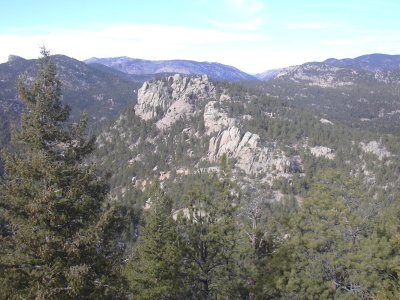
Rowell Hill from Point 6918B north summit, 01/10/09

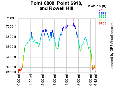
Elevation versus distance, 01/10/09
These peaks are just off US Hwy 36 between Lyons and Pinewood Springs. Two of the peaks are on Gerry Roach's Boulder County Peaks list. Rowell Hill has rank 74 on the list, and Point 6918 has rank 76.
You can see the GPS tracks for this entire hike.
From Lyons, we headed west on Hwy 36, and parked just off the highway near the first wide pulloff, after the road begins its steep climb out of the North St Vrain Valley. There is a dirt road there that ascends the southwest slope of Point 6808 for about 2/10 mile. We started hiking at 10:22, taking the dirt road to its end, then making a beeline to the 6808 ridge. On the ridge we turned right onto an old road which hasn't been used for decades, and left the road as we neared the 6808 summit.
We reached the top of Point 6808 at 10:53, with the odometer at 1.03 miles. This summit has a panoramic view. From it, we took pictures of Button Rock, Point 6918, and Hwy 36 with Longmont Dam Road. There was no summit register there, but lots of white bird drippings. This summit is apparently a favorite perch of a raven, who cruised by us later when we were on Point 6918.
From Point 6808 we headed northwest along the ridge to the saddle between Point 6808 and 6918, and continued in same direction on the ascent to 6918.
The topomap was ambiguous as to where the summit of Point 6918 actually was. There are two knobs that the topo shows have the same level of contour lines. One knob has an X on it, the other has an elevation. It looked like one, or the other, was misplaced. Calling the south knob 6918A and the north 6918B, we visited them both.
We stopped first at 6918A, which has trees on the top, but does have views of Rowell Hill and Button Rock. There was no register, USGS marker, or cairn there. We then went over to 6918B, getting there at 11:46, with the odometer at 2.18 miles. This knob is further ambiguous because it has two subknobs whose heights are also about equal. Neither the south or north subknobs have registers or USGS markers, but the south subknob had a few rocks piled together, looking like it formerly contained a register.
Realizing that we hadn't gotten a GPS elevation on 6918A, we headed back there, before turning to Rowell Hill. Back at 6918A, the odometer showed 2.63 miles. The GPS elevations that we got on 6918A and the two subknobs of 6918B were so close, that considering their accuracy, you couldn't say one was higher than the other.
Heading toward Rowell Hill, we continued northwest along the ridge to the saddle between 6918 and Rowell Hill. An old road, which is a continuation of the previous road we had been on, goes to the saddle. From the saddle, we began our ascent up Rowell Hill. We heard barking dogs near the saddle and soon saw a couple german shepards, but they stayed their distance. There is a house near this saddle, on the southwest side.
Nearing the summit of Rowell Hill, it became a maze of gigantic boulders. It took a long time to navigate and scramble through this maze to get to the summit. We first tried an ascent from the northwest side, but deeming that to be unreasonable, circled around the summit area in a clockwise direction, finally achieving the summit from the south. We reached the Rowell Hill summit at 13:21, with the odometer at 4.12 miles.
We did not find a summit register or USGS marker on the Rowell Hill summit. There is a great view of Point 6918A and B from the summit, as well as Button Rock, Hwy 36, and Blue Mountain.
Heading back the way we came, we stopped for lunch before returning to our parking place at 14:45, with the odometer at 5.8 miles.
The total time for this hike was 4 hrs 23 minutes, with a total elevation gain of about 2,000 feet.
- Richard Hollos and Stefan Hollos
| Place name | Elev [ft] | Accuracy [ft] | Lat/Lon |
|---|---|---|---|
| Parking off Hwy 36 | 6114 | 15 | 40.24407,-105.33013 |
| Point 6808 | 6824 | 6 | 40.24213,-105.32352 |
| Point 6918B, north knob | 6938 | 7 | 40.25088,-105.32850 |
| Point 6918B, south knob | 6933 | 7 | 40.25067,-105.32888 |
| Point 6918A | 6938 | 7 | 40.24952,-105.33129 |
| Rowell Hill summit | 7044 | 7 | 40.25530,-105.33683 |