South Sheep Mountain (8,300 ft) via Dry St Vrain Trail, 11/08/2008

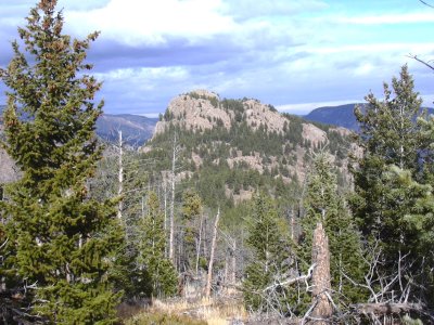
South Sheep Mtn from Point 8171, 11/08/08

Dry St Vrain Trailhead, 11/08/08

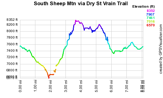
Elevation versus distance, 11/08/08
South Sheep Mountain is on the south side of North St Vrain Canyon, one of the natural wonders of Boulder County. It lies directly across the canyon from North Sheep Mountain. The canyon between these two mountains is very narrow, and scenic. Other nearby named peaks are Cook Mtn to the northeast, and Big John Mtn to the southwest. South Sheep Mountain is number 62 on Roach's Boulder County Peaks List.
You can see the GPS tracks for this entire hike. There are some gaps, due to the GPS not tracking.
From Lyons, we headed up Colorado Hwy 7, and just before Riverside, after mile marker 22, turned right at a bunch of mailboxes. This is Forest Road 185, but is unmarked. Turning right at each intersection, we continued for about 2 miles, where we parked on the side of the road behind a national forest property sign.
From where we parked, the Dry St Vrain Trailhead is another 0.3 miles down the road, and it has a nice parking area, but this last piece of road is rough, so we walked in the last 0.3 miles.
We started hiking down the road at 9:37, and soon got to the Dry St Vrain Trailhead, where the sign there says "North St Vrain Creek, 2 miles". This hike is unusual in the sense that it starts by descending 900 feet to the North St Vrain Creek, and from there we ascend 1,700 feet to the summit of South Sheep Mountain.
Soon after the trailhead, there is a fork in the trail. You want to stay to the right where the sign says "TRAIL". Going left will take you to a nearby small lake.
Reaching the North St Vrain Creek, the odometer showed 1.94 miles. At the creek, we headed upstream, staying on its south bank. Reaching the confluence of the North St Vrain and Dry St Vrain creeks, we turned northwest, ascending the steep slope of South Sheep Mountain.
On the way up, where the way briefly flattens out before the last steep stretch to the summit, we caught a beautiful glimpse of Deer Ridge and Mt Meeker behind it. From there to the summit, the terrain gets very rugged, and is a bit slow going.
We reached the South Sheep Mtn summit at 12:03, where the odometer showed 3.51 miles. The last few feet to the summit requires some scrambling. Some impressive views on the summit are North Sheep Mtn, North St Vrain Creek almost directly below, and Button Rock Reservoir in the distance.
The summit register showed Luke Plumely and Buster were there on Jan 6, 2008. The last signing on the register was Oct 7, 2008 by Ron Spoerl of Boulder, and Craig Hickethier.
We left the summit area at 12:29, heading southwest down the long South Sheep Mtn ridge, getting to Point 8171 at 13:04, where the odometer showed 4.81 miles. Continuing down the ridge, we went south, then east to cross the Dry St Vrain Creek, then ascended to a small lake near the Dry St Vrain Trail. We had lunch at the lake, then followed a faint trail at the lake's north end back to the Dry St Vrain Trail.
Returning to our parking place at 14:44, the odometer showed 7.48 miles. This hike took 5 hrs, 7 minutes. The total elevation gain was about 2,300 feet.
A map of the Dry St Vrain Trail and more info can be found at this Forest Service pdf page.
- Richard Hollos and Stefan Hollos
| Place name | Elev [ft] | Accuracy [ft] | Lat/Lon |
|---|---|---|---|
| Parking | 7549 | 10 | 40.18388,-105.41329 |
| Dry St Vrain Trailhead | 7467 | 12 | 40.18782,-105.41369 |
| Low point at N St Vrain Creek | 6644 | 46 | 40.20661,-105.40812 |
| South Sheep Mtn summit | 8339 | 7 | 40.20885,-105.42619 |
| Point 8171 | 8205 | 16 | 40.20034,-105.43084 |