2015-01-25 Button Rock Mtn
From Lyons, we headed west on Hwy 36 for about 10 miles, then turned left onto Larimer County Rd 47, going about 3 miles, then parking on the roadside where Forest Road 118 begins. With a 4WD vehicle, one can continue about 1/2 mile up the forest road to the closed gate, but this time of year it's snowy and icy.
Hiking up the forest road, starting at about 11:00, we turned left at the saddle where the Coulson Gulch Trail begins, onto another forest road. Heading east, then northeast on the forest road, we continued until about where it crosses the Larimer-Boulder County line. There we departed the road, heading south, then east, ascending Button Rock Mountain. The forest got thicker on the way up, and finally we scrambled up a rock wall to reach the summit plateau.
Button Rock Mountain is a strange one, having a very large plateau on its top, with the summit rock lacking a view and rather challenging to locate, and a south summit about 3/10 of a mile away, with outstanding views. We walked by the summit rock without stopping, and headed to the mountain's south end. It was a trudge to get there, through enough snow to slow us down.

2015-01-25 Ralph Price Reservoir from Button Rock Mtn south summit
We reached the south summit at around 13:30, taking a number of pictures with great views of Kenny Mountain, Meeker and Longs, North and South Sheep Mtn, Cook Mtn, and Ralph Price Reservoir. On the summit of South Button Rock Mountain, there is a USGS marker with date 1955, but no elevation shown.
For our return, we descended the mountain in a more northerly direction from the incoming. The snow was deeper this way, but it was a more direct way down. The rest of the way was slight variations on the incoming tracks. We returned to our parking place at 16:01.

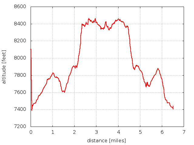
2015-01-25 Elevation profile: Button Rock Mountain
| Place Name | Elev [ft] | Accuracy [ft] | Position (lat,lon) |
|---|---|---|---|
| Parking @ start of Forest Rd to Coulson Gulch | 7433 | 23 | 40.25740,-105.40646 |
| South Button Rock Mtn summit | 8442 | 20 | 40.24638,-105.39028 |
© 2012-2015 Stefan Hollos and Richard Hollos
Tweet

blog comments powered by Disqus