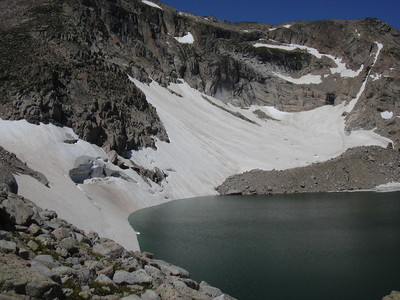
2013-07-21 Moomaw Glacier and Frigid Lake

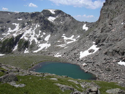
2013-07-21 Isolation Lake
You can see the GPS tracks for this entire hike.
The video shows: Hunters Creek (0:00-0:10), entrance to Box Lake (0:11-0:29), Box Lake (0:30-1:28), Eagle Lake (1:29-2:15), Inlet of Eagle Lake (2:16-2:58), high above Eagle Lake (2:59-3:49), Eagles Beak, Moomaw Glacier and Frigid Lake (3:50-4:36), Mahana-Isolation Pass (4:37-5:23), Isolation Lake (5:24-5:35) Ptarmigan at Isolation Lake (5:36-5:55) Pipit Lake (5:56-6:20) Bluebird Lake (6:21-6:48).
Starting at 7:21 from the Wild Basin Ranger Station we headed up the main trail for 1.4 miles, then turned right onto the campers bypass trail which goes 1.3 miles to the Thunder Lake Trail.
We took the Thunder Lake Trail to an elevation of 10,564 feet where we departed the trail at 9:32, turning left after crossing a bridge at position (40.22301,-105.63846). It had been a few years since we visited Box and Eagle Lakes, so it took us a little while to get our bearings after leaving the trail, but Stefan finally recognized the way to Box Lake.
Stopping for a drink of water at Box Lake while enjoying the view and solitude, we then headed southwest to Eagle Lake, then along the north shore of Eagle to its inlet, which required a little krummholz wading. From the shore of Eagle, there is a fantastic view of Eagles Beak and the way up the Divide via Indigo Pond.
We crossed over the inlet of Eagle Lake using the stepping stone we had thrown in many years ago, which remarkably was still in the same place despite the snow and ice of winter. Heading southwest, we began a steep ascent up the granite terraces interspersed with tundra wildflowers. As the climb leveled out, we turned northwest where we could see the terminal moraine of Moomaw Glacier. Climbing up the moraine, suddenly the glacier and Frigid Lake came into view. The view is dramatic, with the glacier plunging into the lake at a steep angle, and to the right of the glacier, Eagles Beak Rock rises above the lake.
From Frigid Lake, we headed southwest, over a boulderfield and snowfield, then tundra to the top of the Mahana-Isolation Pass. We reached the high point on Mahana-Isolation Pass at 12:34 at an elevation of 12,324 feet. We sometimes get visions of this place in the middle of winter, as a kind of withdrawal symptom from the alpine tundra of summer. Many years ago on this pass, we observed two ravens flying closely above us, investigating who we were.
As we descended from the pass down toward Isolation Lake, we saw 2 figures coming down from the Mahana Peak summit toward the pass. We later talked to them as they told us they had camped at Upper Ouzel Campground and had started that morning at 6 am, climbing Isolation Peak, then Mahana.
We stopped for lunch at Isolation Lake, a small turqoise colored lake below the ridge of Isolation Peak. As we were eating lunch, we heard clucking sounds, which turned out to be a ptarmigan with chicks only a few feet away.
From Isolation Lake we descended south, then southwest, as we passed by the northeast side of Pipit Lake where we took a picture of the prominent cubic monolith (erratic) near the lake edge.
From Pipit we made our way through a few scratchy krummholz spots on the way to Lark Pond then Bluebird Lake. You can still see remnants of Longmont's dam at the outlet of Bluebird Lake. We took the Bluebird/Ouzel Lake Trail back to the Ouzel Falls/Calypso Cascades Trail, but didn't go by Ouzel Falls and Calypso Cascades. Instead we turned left on the trail, going 0.3 miles back to the campers bypass trail which we came in on.
We returned to the Wild Basin Ranger Station and parking area at 17:31. The GPS tracks show total distance traveled at 15.9 miles. The elevation difference from lowest (parking at Wild Basin Ranger Station) to highest (Mahana-Isolation Peak Pass) was about 12,300-8,500 = 3,800 feet. The total trip time was 10 hrs, 10 minutes.
Things we saw on this hike: white crowned sparrow, robin at Box Lake, broad-tailed hummingbird near Ouzel Lake, new purple cones on subalpine firs, bistorts, mertensias, fireweed, ptarmigan with babies at Isolation Lake, gray squirrel, pika, lady bugs on shore of Eagle Lake, ground squirrels begging for snacks (they've been trained).

2013-07-21 Elevation profile: Wild Basin Ranger Station to Box Lake, Eagle Lake, Frigid Lake, Isolation Lake, Pipit Lake, Bluebird Lake, and back to ranger station
| Place Name | Elev [ft] | Accuracy [ft] | Position (lat,lon) |
|---|---|---|---|
| Parking at Wild Basin Ranger Station | 8,468 | 23 | 40.20792,-105.56687 |
| Departed Thunder Lake Trail | 10,564 | ? | 40.22301,-105.63846 |
| Mahana-Isolation Peak Pass (high point) | 12,324 | 13 | 40.20138,-105.66882 |
© 2012-2013 Stefan Hollos and Richard Hollos
Tweet

blog comments powered by Disqus