This post covers our trip to the Spanish Peaks and Great Sand Dunes National Park on October 17-21, 2021.
On October 17 we headed south from Longmont, Colorado on I-25 for 175 miles to Walsenburg, Colorado. From Walsenburg we headed west on US Hwy 160 then south on Colorado Hwy 12 to La Veta, Colorado. The distance from Walsenburg to La Veta is 16 miles.
On reaching La Veta, it was nearing sunset, so we were keen on finding a place to spend the night in the back of our truck. Being Sunday evening, the La Veta Visitor Center was not open, but we picked up a brochure about attractions of Huerfano County. In the brochure was a mention of the Southern Colorado Astronomical Park described as being one mile west of La Veta. We thought that might be a nice place to spend the night, but were unable to locate it, so we ended up spending the night in our truck at Daigre Reservoir, just east of La Veta.
Following breakfast, we walked around Daigre Reservoir, which had a beautiful backdrop of the Spanish Peaks and Rough Mountain in the early morning light.

2021-10-18 Rough Mountain from Daigre Reservoir
We then went back to La Veta, then south on Colorado Hwy 12 to Cuchara. There we hiked the Dikes Trail that starts on the edge of town at Cuchara. This trail is wooded, with mostly scrub oak. We eventually got a nice view of the western side of the Cuchara Valley, including the ski area, which you can see in the video below.
On returning to our truck, we drove to Cordova Pass on Colorado Hwy 12, then Forest Rd 415. The forest road is 6 miles of gravel and dirt, and already there were a few patches of snow on shady parts of the road. The pass has a parking area and campground. We got there at around 15:30, and since the summit of West Spanish Peak is only about 3 miles from there, we thought we might be able to just run up to the top. So we took off with nothing but a t-shirt and sweater. We got to about 100 feet above treeline when we realized that the cold and the wind was going to make it impossible to continue, so we had to turn around or risk becoming frozen mummies.

2021-10-18 West Spanish Peak
Returning to our truck, the area was empty of people and cars, where a couple hours before it was bustling. Due to the altitude and cold, we decided not to spend the night at the pass, and ended up driving back to La Veta for another night at Daigre Reservoir.
In the morning we drove back to La Veta, and looked for a place to fill our water bottles. The visitor center was closed. At the La Veta Public Library, there was a lady sweeping the front porch, so we asked her if she knew of a place where we could fill our water bottles. She told us she would ask Tony (Anthony Masinton, director of the library). She went inside, and soon came back out with Tony who said we could bring our bottles inside the library to fill them. He took us to the library's kitchen sink where we gladly filled them. It was nice of Tony to let us fill them, especially since the library was not yet opened. Tony said he's been drinking the La Veta tap water for 7 years and is still alive. We later realized what he meant, when we tasted the water, as it has a tea-like taste, ostensibly due the tannins in all the oak leaves that fall into the Cucharas River which is the town's water supply.
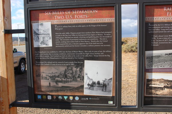
From La Veta, we headed north on Colorado Hwy 12 to US Hwy 160 then west to La Veta Pass. Heading down the other side on US Hwy 160 to Fort Garland there is a pulloff that has solar powered street lights and interesting historical displays on the human settlement of the area, including Fort Garland and Fort Massachusetts which was at the base of Mount Blanca, as well as the Native American residents of the San Luis Valley, and the Spanish Conquistadors.

2021-10-19 Highway history display for Fort Massachusetts and Fort Garland
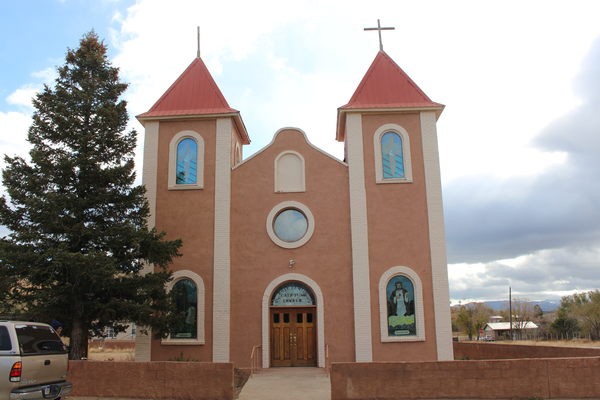
Continuing west on Colorado Hwy 160, we stopped at the beautiful Fort Garland Catholic Church with its stained glass windows. Unfortunately the door was locked.

2021-10-19 Fort Garland Catholic Church
From Fort Garland we continued west on US Hwy 160 to Blanca, Colorado, then after about 5 miles we turned north onto Colorado Hwy 150. Almost immediately after turning, there is a pulloff on the right side with several interesting historical information displays as well as a Great Sand Dunes display.

2021-10-19 Highway history display for Los Caminos Antiguos
A couple miles after that, on the right, is a BLM campground called "Sacred White Shell Mountain", which is what the Navajo called Mount Blanca. Here you can camp anywhere off the dirt road.
We continued north about another 10 miles to the sign for the "Zapata Falls Recreation Area" where we turned right and drove up to the Zapata Falls Campground. Finding a spot at the campground was easy, there were only a couple other campers there. In the late afternoon we hiked over to Zapata Falls from our campsite.
We spent a cold night at the campground which is at an elevation of 9000 feet. By the morning, our truck topper windows where we slept had a thick layer of ice. We warmed up in the morning by putting our hands near our propane stove flames, then boiled water with the stove and drank the wonderfully hot water.
From the Zapata Falls Campground, we drove back down to Colorado Hwy 150, and turned north to the entrance of Great Sand Dunes National Park, then on to the parking area for the dunes. We replaced our hiking boots with sandals and headed out onto the dunes.
The dunes had a great positive effect on us. The natural beauty of the dunes was incredibly inspiring. It's a fluid dynamics and granular materials laboratory on a massive scale. Sunlight illuminating the dunes reveals the elegant mathematical curves produced by the interplay of sand, wind and gravity. The sand exposed to the sun quickly warms up, and it was wonderful to feel the warm sand engulfing our toes on the dune's sunny side in contrast to the cool sand on the shady side. The few plants on the dunes illustrate the tenacity of life in a shifting landscape.

2021-10-20 Sand dunes
After 2 1/2 hours of dune hiking, we headed back. After lunch we went over the the visitor center. When the visitor center closed at 16:30, we sat on benches behind the building admiring the vast beauty of the dunes before us. Soon a guitar slinging park ranger (Patrick Meyers) showed up with some visitor center employees. They invited us to join them in a picture taking event. Ranger Meyers then sang us an old song called "The Singing Sands of Alamosa".
That evening we spent the night in our truck at a pulloff along Colorado Hwy 150 south of the Great Sand Dunes entrance, where we joined an RVer for a night of free camping.
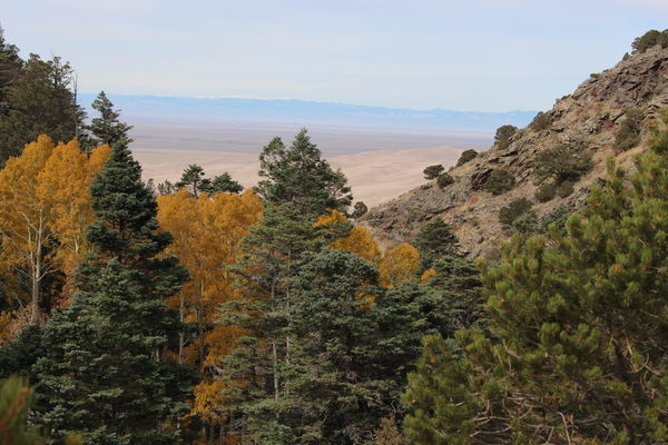
In the morning we headed back into the park, parking at the Mosca Pass Trailhead, where after breakfast, we warmed up our cold bodies by running the 3.25 miles up to the pass in about an hour. We had hoped for a great view of the dunes from there, but we found only a modest one.

2021-10-21 Dunes from Mosca Pass
After the Mosca Pass excursion, we headed south to US Hwy 160, then west to Alamosa where we filled our tank, then north on Colorado Hwy 17 to Mosca, Hooper and Moffat. Along this stretch of highway you can see the west side of the dunes. After Mineral Hot Springs, we got onto US Hwy 285 to Poncha Pass, then north to Poncha Springs. We ended up spending the night at the Ruby Mountain Campground along the Arkansas River near Nathrop, Colorado.
In the morning, we continued on US Hwy 285 to Johnson Village, then up to Trout Creek Pass, Antero Junction, Fairplay, Red Hill Pass, and Kenosha Pass.

2021-10-22 Colorado Trail near Kenosha Pass
At Kenosha Pass, we did a small hike heading west on the Colorado Trail, then continued east on US Hwy 285 to the eastern edge of Lakewood where we turned north onto Colorado Hwy 470 to 6th Ave in Golden, then took Colorado Hwy 93 north to Boulder, and finally Longmont.
We thoroughly enjoyed this trip. In October, the crowds of summer are gone, which we benefitted from in finding places to camp and in visiting the Great Sand Dunes. The cooler temperatures made the dunes perfect for a visit, but did require more insulation for camping comfortably. One thing to keep in mind about camping in October is that campground water faucets have been turned off like at Zapata Falls, and at the feet washing area of the Great Sand Dunes.
© 2012-2021 Stefan Hollos and Richard Hollos
Tweet

blog comments powered by Disqus