You can see the GPS tracks for this entire hike.
The video shows: Lion Gulch Creek (first 44 seconds), Homestead Meadows (0:45-1:35), view from knob on southeast ridge of Lionhead (0:45-1:35), view from Lionhead summit (2:10-2:28), meadow between Pierson Mtn and Lionhead (2:29-2:50), Hill Homestead (2:51-3:15), Lion Gulch Creek (3:16-end).
We started hiking at 9:50 from the Lion Gulch Trailhead off U.S. Hwy 36 between Pinewood Springs and Estes Park. At Homestead Meadows, just past the Griffith Homestead, we reached a dirt road that says "Private Property". Avoiding the private property, we turned left onto another dirt road, which shortly crossed a more well worn dirt road. After crossing this dirt road, the road we were on became very faint as it entered forest. We followed this faint road up the east side of Lionhead as it faded into a trail, then disappeared entirely.
It was a steady steep climb through the forest until we topped out on a knob on the southeast ridge of Lionhead. There was a great view here as shown on the video, with the summit rock visible to the northwest. We followed the ridge northwest until we got to the actual summit, reaching it at 12:22, with the odometer at 4.32 miles. The summit has fantastic views as shown on the video, including the Twin Sisters, Estes Park, the high peaks of RMNP, and Big Elk Meadows.
The Lionhead summit register showed someone had just signed it today: Kurt Johnson, Nancy Bell, and Jack (paw prints) from Estes Park. Before that, March 8 was the last signing.
For the descent we headed southeast along the ridge for a short distance, then carefully made our way off the rocky ridge in a southern direction, and finally headed west through forest down the west side of Lionhead to the Pierson-Lionhead saddle. The area near the saddle and extending southeast is an idyllic meadow interspersed with aspen.
From the saddle, we headed southeast along the drainage that becomes Deer Creek. The first homestead below the Lionhead-Pierson saddle is the Hill Homestead which was sold by Clayton Hill in 1921 to Daisy Baber, author of Injun Summer and The Longest Rope. Copies of her books are still available. The one review for Injun Summer at Amazon says the subject of the book, Bill Walker, is buried in Lyons Cemetery.
From the Hill Homestead, we continued southeast along the trail, which becomes a dirt road, turning northeast, eventually ending up through a network of dirt roads, at the entrance sign to Homestead Meadows.
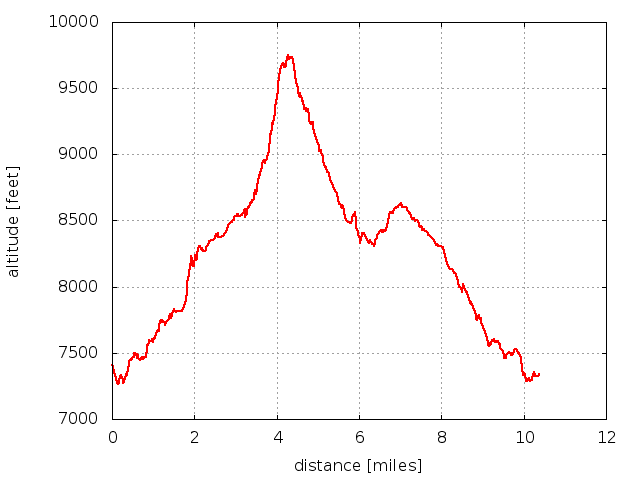
We returned to the Lion Gulch parking area at 16:08 with the odometer at 10.37 miles. The elevation difference from the low point on the Little Thompson to the Lionhead summit is 2,427 feet. Below is the elevation profile.

2013-05-18 Elevation profile: Lion Gulch Trailhead to Lionhead
| Place Name | Elev [ft] | Accuracy [ft] | Position (lat,lon) |
|---|---|---|---|
| Lion Gulch parking area | 7,405 | ? | 40.31507,-105.40547 |
| Low point on Little Thompson | 7,330 | 23 | 40.31388,-105.40509 |
| Lionhead summit | 9,757 | 16 | 40.30953,-105.46807 |
| Lionhead-Pierson saddle | 9,354 | 30 | 40.30900,-105.47193 |
© 2012-2013 Stefan Hollos and Richard Hollos
Tweet
blog comments powered by Disqus