Parked just after Peaceful Valley Campground, and before Camp Dick, near the Bunce School Road intersection. Beginning at about 9:15, hiked north on Bunce School Road. Jeeps and ATVs prompted us to leave the road, and we headed cross country northwest.

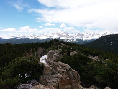
2014-06-01 Mt Audubon from summit of 10583
Dense bushwacking for awhile, then the forest gets sparser and the going's easier. As we ascend, the snow gets thick enough to slow us down. Deep snow on northeast facing slope, then mostly dry on southeast facing slope.
Reached the ridge top, then it's less climbing, northeast to the summit. We pass through a limber pine forest, with ancient one on knob before summit. Summit has high winds, getting there at 12:30. We're blown around as we take pics. Register is missing, with only broken jar remaining. Quite a view on top, with Mt Audubon, Meeker, and St Vrain.
On return, we form a clockwise loop, and head down mostly dry southeast facing slope. Not focusing on terrain, Richard twists his ankle. It's a slow hobble back. Eventually reach 4WD road. Find group of jeeps trying to get one unstuck from mud.
Getting back to truck at 14:45, we drive to Buchanan Pass Trailhead for lunch by the creek. We find a woman painting a creekside scene. The creek is loud and crazy high.
Total hike time about 5 1/2 hours. Distance traveled was 6.5 miles. Altitude difference from lowest (parking at 8,602 ft) to highest (10,622 ft) was about 2,000 ft.

2014-06-01 Elevation profile: Point 10583 from Peaceful Valley
| Place Name | Elev [ft] | Accuracy [ft] | Position (lat,lon) |
|---|---|---|---|
| Parking near Bunce School Rd @ Peaceful Valley | 8602 | 23 | 40.13199,-105.50863 |
| Point 10583 summit | 10622 | 13 | 40.15375,-105.52246 |
© 2012-2014 Stefan Hollos and Richard Hollos
Tweet

blog comments powered by Disqus