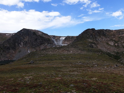
2013-09-08 Ridge between Skyscraper and Bob and Betty Lakes (Bob at far left)
You can see the GPS tracks for this entire hike.
We started hiking at 8:56 from the side of the road before the Hessie Trailhead. At the junction of the King Lake Trail and the Devils Thumb Bypass Trail, we turned right onto the Devils Thumb Bypass Trail.
At the next junction we turned left onto the Devils Thumb Trail, then after a short distance turned right onto the Woodland Lake Trail. This trail we took to its end at Skyscraper Reservoir.
We crossed over the outlet of the reservoir, below the remnants of the dam, then southwest over trackless tundra to the east ridge of Peak 11893. Following the ridge west to the summit of Peak 11893, we then descended its northwest ridge to a saddle overlooking Bob and Betty Lake.
At the saddle, we could see part of Bob Lake and a small glacier below the divide that's not on the topo map. We descended the saddle southwest to the north shore of Betty Lake, then went around the lake clockwise, soon meeting with the Bob and Betty Lake Trail. On the Bob and Betty Lake Trail, we descended to the King Lake Trail, and returned via that trail.
Returning to the parking place at 15:04, the GPS data shows total distance traveled at 12.0 miles. The high point was Peak 11893 and the low point at the parking spot was about 8,900 feet, making a difference of about 3,000 feet.

2013-09-08 Elevation profile: Skyscraper Reservoir to Betty Lake Loop
© 2012-2013 Stefan Hollos and Richard Hollos
Tweet

blog comments powered by Disqus