2013-06-08 St Vrain Mtn from St Vrain Mtn Trail
You can see the GPS tracks for this entire hike.
The video shows: On the trail going up (start-0:32), St Vrain-Meadow Mtn saddle (0:33-1:07), ascending east ridge of St Vrain Mtn (1:08-1:27), on the summit (1:28-2:08), descending on snow (2:09-2:27), timberline (2:28-2:50), north branch of Rock Creek (2:51-3:43), return to trailhead (3:44-end).
We started hiking from the St Vrain Mtn Trailhead at 9:40. We soon came upon two separate treefalls that completely blocked the trail. Hopefully the forest service will clear those soon.
Higher up, patches of snow began appearing, but nothing significant enough to slow us down. Up at the St Vrain-Meadow Mtn saddle we could see Meadow Mtn was clear of snow on its south side, but the east-northeast side of St Vrain Mtn showed lots of snow. It was a bit breezy as we headed to St Vrain Mtn, and the flat area - before the climb gets steep - was fairly wet with patches of soft snow.
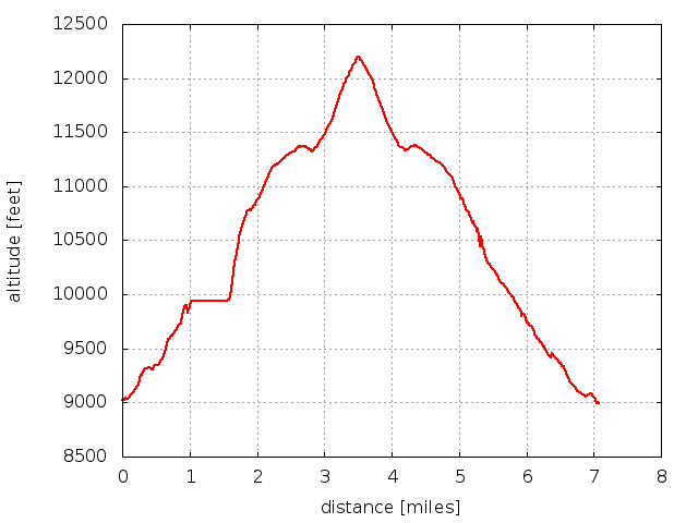
Fortunately, when we began ascending the snowy east ridge of St Vrain Mtn, the snow was hard enough to allow for a speedy climb up. We reached the St Vrain Mtn summit at 11:38 with the GPS tracks showing a distance of 3.5 miles.
As usual the view from the summit was fantastic, with the snowy divide to the west. A pika was chirping and running around near us. A brisk wind and the look of developing thunderstorms, prompted us not to stay long.
The descent was great fun, with a seemingly effortless slide down the snowfield. On the way down, we stopped for lunch and at numerous places along the creek (north branch of Rock Creek).
We returned at 14:47 with GPS tracks showing distance traveled at 7.1 miles. Other data from GPS tracks: minimum altitude = 8989.5 ft, maximum altitude = 12201.4 ft, max-min difference = 3211.9.

2013-06-08 Elevation profile: St Vrain Mtn Trailhead to St Vrain Mtn summit and back
| Place Name | Elev [ft] | Accuracy [ft] | Position (lat,lon) |
|---|---|---|---|
| St Vrain Mtn Trailhead | 8,993 | 20 | 40.17414,-105.53342 |
| St Vrain Mtn summit | 12,206 | 16 | 40.16127,-105.58572 |
© 2012-2013 Stefan Hollos and Richard Hollos
Tweet

blog comments powered by Disqus