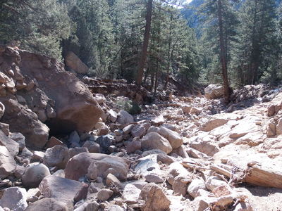
While the the flood of September 2013 has been tragic and devastating, it has also produced opportunities to learn and explore for geologists and rockhounds in the St. Vrain watershed.
Driving up Hwy 7 from Lyons, there are numerous washouts from the flood visible from the highway. The one we chose to explore on this day is about 0.2 miles west of mile marker 25, about a mile past Barking Dog Rock. You can see the tracks for this entire hike (ignore the noise spike).

2014-03-16 Washed out gulch near Hwy 7 marker 25
We parked at a wide pulloff on the left (south) side of the road, then crossed the road, to the washout on the north side. Following the dry creek bed north, we were amazed by the destruction, with uprooted trees, boulders, and rocks scoured and moved by the floodwater. There was seemingly every type of rock visible in the creekbed; mixed in with the native pink granite are rocks common to the recently glaciated terrain near the divide many miles to the west. How did these rocks get here?, we wondered.
Ascending the creekbed while exploring the rocks, we kept to the right at a fork in the creek, then eventually had to leave the creekbed at about 7400 feet when things became unreasonably steep and unstable. We turned right (east) into ponderosa forest, then north through a notch in the ridge's granite wall, reaching a plateau, near some residences off Conifer Hill Road. Our high point was nearly 8300 feet.
For our return, we descended through the notch again, but then departed our incoming tracks by heading south along a forested and meadowed slope that turned out to be easier terrain than our ascent. We stopped for lunch at an overlook above Hwy 7 before continuing our descent. There are bluffs above the highway, which we avoided by heading west to the creek, then south to the road.
From near the highway, we explored another smaller washout heading northwest.
The altitude difference from lowest (parking at about 6800 ft) to highest (8200 ft) was about 1400 feet, and the total distance traveled is unknown due to noise spikes in the GPS.
| Place Name | Elev [ft] | Accuracy [ft] | Position (lat,lon) |
|---|---|---|---|
| Parking off Hwy 7 near washout | 6816 | 39 | 40.17070,-105.37823 |
| Notch in granite wall to ridge top | 8214 | 33 | 40.17969,-105.37663 |
© 2012-2014 Stefan Hollos and Richard Hollos
Tweet

blog comments powered by Disqus